Continue to Site

Eng-Tips is the largest engineering community on the Internet

Intelligent Work Forums for Engineering Professionals

  • Congratulations cowski on being selected by the Eng-Tips community for having the most helpful posts in the forums last week. Way to Go!

Rockport Tx

Status
Not open for further replies.

kipfoot

Structural
Oct 25, 2007
493
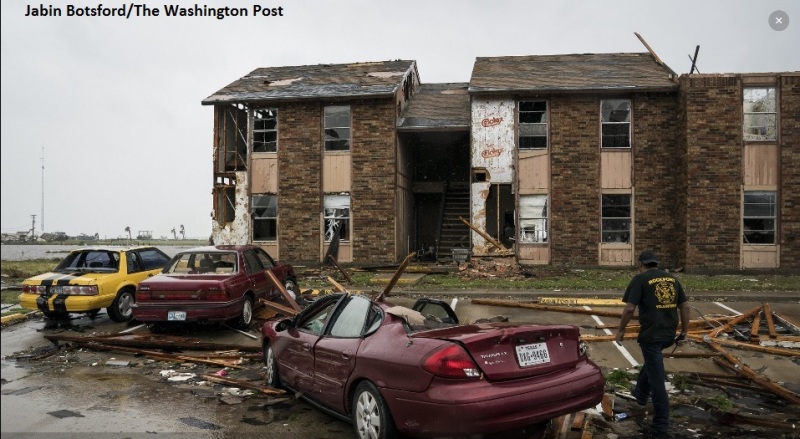
Some construction methods were revealed by the hurricane winds in Rockport Texas. Comparison of news photos with google maps shows catastrophic (and perhaps fatal if the residents didn't evacuate) damage at wood framed apartments. I"m not from this area, but if I've correctly identified these apartments, they're a block from the water's edge and stylistically look like they're from the 1980's. Veneer brick pulled off. Roof sheathing and trusses lifted. Celotex sheathing.

look at street view google maps: salt grass landing apartments rockport tx
washington post (scroll down to 'photos') article link
 
I'm not seeing the photos in question.
Looking on Google maps, it looks like that whole area would have gotten wiped clean by storm surge, though.
 
Some of what I was talking about now starts at 34 of 74. They added many more photos.
 
Natural disasters certainly do provide some opportunities to learn about the behavior of structures.

I arrived in the San Fernando Valley (LA area), CA area the day before the Northridge earthquake. After the shake, I immediately contacted the NCMA (National Concrete Masonry Association) to see if a few of the engineers would be out to investigate. Fortunately, my boss gave me the green light to tag along with my industry friends during the observations.

The results and damage were generally by the text books, but some of the erratic results did offer some information for code improvement and eliminate some of the "old hat" practices, especially for the lower floors.

I assume the effects of the area damage and effects on the infrastructure will result in some changes there and elsewhere.

I spent about 3 months around Gulfport after Katrina and was surprised to see the results where the outflow with debris actually did more damage the the initial 20-28 foot surge. I am sure there are still a lot of unknown elements that were built up in the shallow offshore from the debris (cars, etc.).

Dick


Engineer and international traveler interested in construction techniques, problems and proper design.
 
Texas coast has been designed for hurricane-force winds since at least ASCE 7-98. Prior to that they were (I believe) using the SBCCI code - anyone happen to have a wind map for that?
 
I'm not sure how all of that has worked through the years. As far as I know, residential building codes in Texas have only been municipal, not county or state wide, so it's possible that a lot of beachhouses didn't meet any particular building code when they were built. One of the major current factors in design down there is the Texas Windstorm Insurance Association, and the state does qualify engineers that do evaluations for wind storm insurance purposes. If I remember right, the TWIA maps are based on IBC, but are broken out into zones along political and other boundaries instead of having to eyeball off of a map.

We moved into Clute in 1964 or so, and as a kid growing up, I remember them pointing out ONE beach house out at Surfside Beach that had weathered the last hurricane. People down there could tell you what flooded and what didn't flood in that hurricane, too.
 
for some clarity, this is one of the photos I linked to initially. Other photos at the linked page have been replaced as the natural disaster continues.
Rockport_gprwwx.jpg
 
Looks like that Celotex is doing its job. We don't need no stinking plywood or roof diaphragm!
 
Status
Not open for further replies.

Part and Inventory Search

Sponsor